

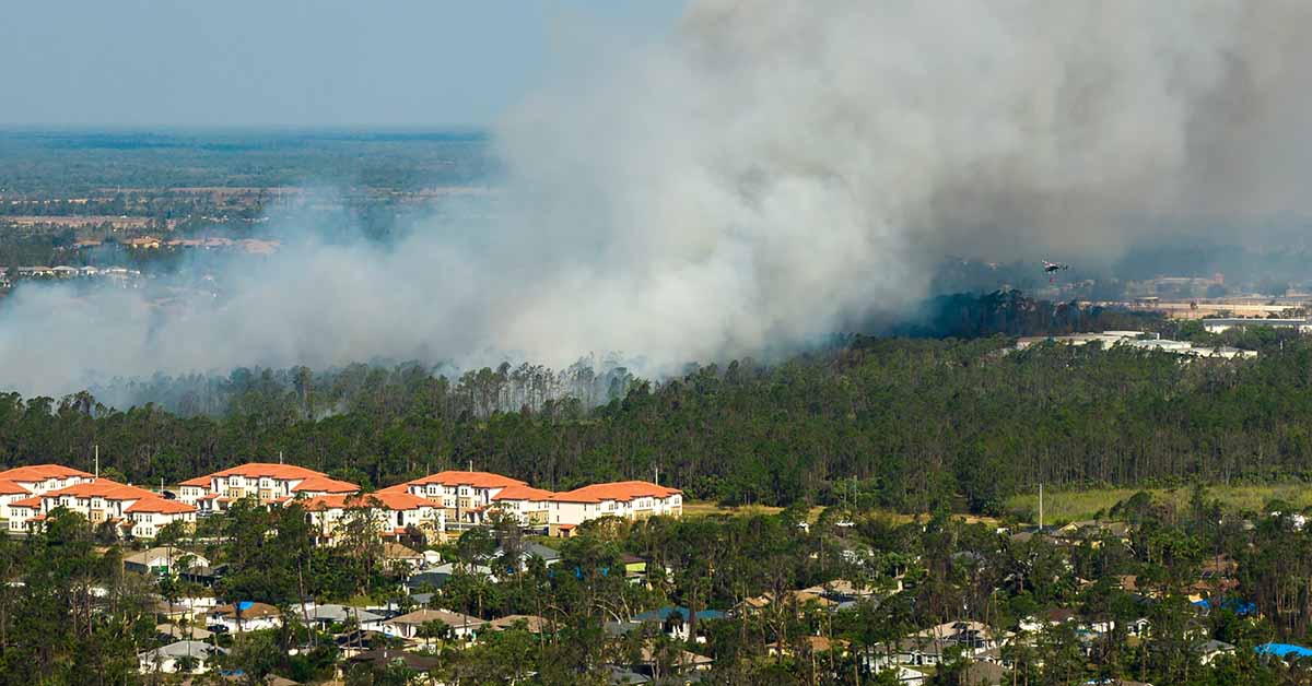
The scope of wildfire risk across the United States has become alarmingly clear and it’s much greater than previously recognized. A new analysis, released by the team at Wildfire Risk to Communities (wildfire risk.org), states that over one-third of the U.S. population live in counties that are at a high risk for wildfires – more than 115 million people. About one-third of all structures, an estimated 48 million buildings, are also in the high risk areas.1
These findings are the result of a change in approach to the analysis. Due to the new norm of larger and more extreme wildfires, the researchers from Missoula Fire Sciences Laboratory and the Forest Service, who are behind wildfirerisk.org, assessed the last 15 years (between 2004-2018). This is a change from the previous analysis which examined a longer period of 34 years, ending in 2012.
Climate change prompted the team to focus on the more recent period and shorter time frame. Read on to learn more about this new norm, how it impacts everyone (not just those living in a high risk county), and what you can do with this information.
The New Wildfire Assessment
Wildfire Risk to Communities is a free, user-friendly website featuring interactive maps, charts, and resources to assist communities in understanding, exploring, and mitigating wildfire risk. Developed by the USDA Forest Service at the behest of Congress, the site is intended for community leaders, including elected officials, planners, and fire managers.
Initially launched in 2020, the website recently received a comprehensive update. The latest updates significantly enhance our understanding of wildfire vulnerabilities affecting communities nationwide – including the fact that approximately ⅓ of the population and structures in the U.S. are at high risk of experiencing wildfires. The new analysis also underscores the urgent need to safeguard thousands of vulnerable communities.
One notable finding is the increased wildfire risk to Pacific Northwest communities. Recent climate trends have heightened the risk, with over 60% of counties in Washington and Oregon now classified as high-risk, up from 47% in previous models.
Additional changes to the updated assessment on wildfirerisk.org include items like enhanced vegetation data for a better understanding of fuel sources and updated weather datasets to more accurately reflect current climate conditions.
Understand, Explore, and Reduce
To explore these updates and learn more about wildfire risks in your community, visit the Wildfire Risk to Communities website (wildfirerisk.org). The three main goals of the Wildfire Risk to Communities website (wildfirerisk.org) are to understand, explore, and reduce the risk of wildfires.
Understand Wildfire Risk
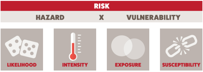
A community’s wildfire risk is a combination of likelihood and intensity (collectively known as “hazard”) and exposure and susceptibility (collectively known as “vulnerability”). Identifying which of these factors impact a community enables experts to prioritize risk reduction efforts effectively.
Explore Wildfire Risk
The “explore” tool on the website allows you to check the level of risk for wildfires in your town, county, or tribal area. Simply go to https://wildfirerisk.org/explore/ and input your information.
You’ll learn:
- Risk to homes in a particular location
- Likelihood of a wildfire in any given year
- Risk reduction zones where mitigation efforts will be most powerful
- Vulnerable populations who are disproportionately impacted due to socioeconomic factors
Reduce Wildfire Risk
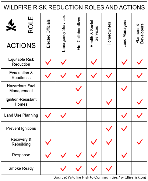
It is crucial for communities to be proactive about reducing and managing wildfire risk. wildfirerisk.org outlines the specific tasks for different community groups and leaders, including homeowners.
The tasks include:
- Equitable Risk Reduction: Confronting the socioeconomic challenges within a community
- Evacuation and Readiness: Evacuation routes, family plans, and community alerts ready for emergencies
- Hazardous Fuels Management: Reducing flammable vegetation with cutting, thinning, burning, etc.
- Ignition-Resistant Homes: Conscious use of wildfire-resistant landscaping and building materials
- Land Use Planning: Plans and regulations directing communities on how to develop wildfire-prone land
- Prevent Ignitions: Stop fires from beginning from debris burning, campfires, vehicles, etc.
- Recovery and Rebuilding: Restoring the community and landscape after a wildfire
- Response: Protect resources, communities, and lives by managing and fighting wildfires
- Smoke Ready: Prepare the community for the health impacts from smoke
The recommended actions vary depending on the role a person or group plays within society. Together, with conscientious planning and action, we can lower the risk and impact of wildfires.
Talking to Children About Wildfires
It’s almost hard to believe that this time last year huge swathes of North America were experiencing historically unsafe air quality levels due to the wildfires in Northeastern Canada. For people in areas that are not prone to wildfires, it was the first time they experienced such extreme air quality issues stemming from wildfires.
One of the defining features of a bad air quality alert is the warning to stay inside with windows and doors closed. It was a particularly challenging discussion for parents to have with kids last year, at the onset of summer and premium playing outside time.
But children are particularly vulnerable to harsh health outcomes due to bad air quality because they are still growing, a more rapid breathing rate, and the greater potential for long-term effects so it is crucial for kids to avoid air quality hazards.
Now that wildfires are projected to impact even more of the population and because wildfire season coincides with summer, parents should anticipate more bad air quality days that’ll be unsafe for the kiddos to play outside.
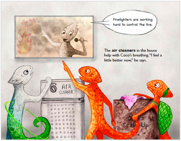
To help with teaching children about the impact wildfires have on air quality, the U.S. Environmental Protection Agency created the children’s book, “Why Is Coco Red?”2 (It is also available to be enjoyed as a short cartoon on YouTube.)3 This educational tool has been designed for all kids but there is a special focus for children with asthma because of the extra hazard that wildfire smoke has on their health.
Combat Wildfire Smoke with Austin Air HealthMate Plus
As wildfire risks and their associated impacts continue to grow, it’s essential to take proactive measures to protect your health and home. With over ⅓ of the United States in a high risk area for wildfires, we can all expect to be impacted like June 2023.
One effective way to combat the harmful effects of wildfire smoke is by using an Austin Air HealthMate Plus purifier. Designed to filter out smoke, pollutants, and other airborne particles, the HealthMate Plus ensures that the air you breathe indoors remains clean and safe. Don’t let wildfire smoke compromise your health—equip your home with an Austin Air HealthMate Plus purifier today.
REFERENCES
1 Ellfeldt, A. (2024, June 2). Wildfires Threaten Nearly One Third of U.S Residents and Buildings. Scientific American. https://www.scientificamerican.com/article/wildfires-threaten-nearly-one-third-of-u-s-residents-and-buildings/.
2 U.S. Environmental Protection Agency. (2022). Why Is Coco Red? U.S. EPA. https://document.airnow.gov/why-is-coco-red.pdf.
3 U.S. Environmental Protection Agency. (2022, October 11). Why is Coco Red? [Video]. YouTube. https://www.youtube.com/watch?v=Jt_pFRrr5Co.